Manaslu Conservation Area at a Glance
Before we go deeper, here are the basic facts you should know.
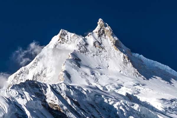
The area was created in 1998. It spans 1,663 square kilometers, all within the Gorkha district of Nepal. The land rises from 1,400 meters to 8,156 meters at its highest point, the summit of Mount Manaslu.
It sits inside the Mansiri Himal range, part of the greater Himalayas. The climate here shifts a lot. You start in warm, subtropical forests and end up in freezing, nival zones near the peaks.
Wildlife lovers will find plenty to admire. The region shelters 33 mammal species, over 110 bird species, three reptile species, and close to 2,000 types of flowering plants. Even rare frogs call this place home.
In short, the region is a small area with a giant range of life packed into it.
Where Is the Manaslu Conservation Area & How to Get There
The Manaslu Conservation Area is in the northern part of the Gorkha district, at the very edge of Tibet. It’s situated just east of the Annapurna region, nestled between two of Nepal’s most iconic mountain regions.
Getting there is part of the adventure. Most trekkers start from Kathmandu and drive to Machha Khola. This is where the actual trail begins.
Here is a simple breakdown:
- Driving time: From Kathmandu to Machha Khola: About 8 to 9 hours by road
- Route type: Local bus, shared jeep, or private vehicle
- Road condition: Mostly paved until Arughat, then rough and winding
- Trailhead elevation: Around 700 meters
From Machha Khola, the trail follows the Budhi Gandaki river upstream. From there you climb gradually to higher villages and finally to the Manaslu Circuit itself.
History: Why and How MCA Was Established?
The Manaslu Conservation Area was created in 1998. The Nepal government set it up under the National Parks and Wildlife Conservation Act. The goal was simple. Protect the region's wildlife and forests while still allowing local communities to live and grow here.
This land does not push people out like a national park. Farmers, herders and teahouse operators still work within its confines. That’s what makes it different.
This area is under the management of the National Trust for Nature Conservation (NTNC). They collaborate with local communities, not impose rules from the outside. This strategy has helped to balance tourism, agriculture and conservation at the same time.
Before 1998, this region had almost no outside visitors. It was closed off due to its location near the Tibet border. Once it opened, trekkers slowly began to discover its trails, though numbers stayed low compared to places like Annapurna. That history is part of why the area still feels so untouched today.
Six Climatic Zones, One Trek
Walk through the Manaslu Conservation Area and you will pass through several different worlds, all in a single trek. The elevation changes fast, and so does the climate.
Here is a simple breakdown of what you will experience:
| Elevation Range |
Climate Zone |
What You'll See |
| 600–1,000 m |
Subtropical |
Warm forests, rice terraces, river valleys |
| 1,000–2,000 m |
Temperate |
Pine and oak forests, small villages |
| 2,000–3,000 m |
Subalpine |
Rhododendron forests, cooler air |
| 3,000–4,000 m |
Alpine |
Open meadows, yak pastures |
| 4,000–5,000 m |
High alpine |
Sparse vegetation, rocky trails |
| Above 5,000 m |
Nival |
Snow, ice, glaciers, no plant life |
This range is rare for a single trekking route. In just a few days, you go from warm river valleys to icy high passes. It also means you need to pack for very different conditions, sometimes within the same week.
For trekkers, this variety is part of the charm. Every day on the trail looks a little different from the last.
Flora of the Manaslu Conservation Area
The plant life here changes as fast as the climate does. As you climb, one forest gives way to another, each with its own character. Some highlights along the way:
- Lower valleys (600–1,000 m): Warm forests with sal trees and bamboo groves
- Mid hills (1,000–2,000 m): Pine, oak, and chestnut forests
- Higher slopes (2,000–3,000 m): Rhododendron forests, especially colorful in spring
- Alpine zones (3,000–4,000 m): Juniper shrubs and open grassy meadows
- Above 4,000 m: Mosses, lichens, and hardy alpine flowers
In total, the region holds close to 2,000 species of flowering plants. That is an impressive number for such a small area.
The best time to see this diversity in full bloom is spring. Rhododendron forests turn shades of red and pink, and meadows fill with wildflowers. Even in autumn, the forests still look rich, just in quieter, earthy tones.
For anyone who loves plants as much as mountains, this trail rarely disappoints.
Wildlife You Could Actually Encounter
This region is not just about mountains. It is also home to some of the rarest animals in the Himalayas. The area shelters 33 species of mammals. The most famous is the snow leopard, though spotting one takes patience and luck. Other animals are more commonly seen, especially if you keep your eyes open along quiet stretches of trail.
Here’s what to look for:
- Snow Leopard: Elusive, mostly active at high and remote elevations
- Musk deer: Small and shy, usually seen at forest edges
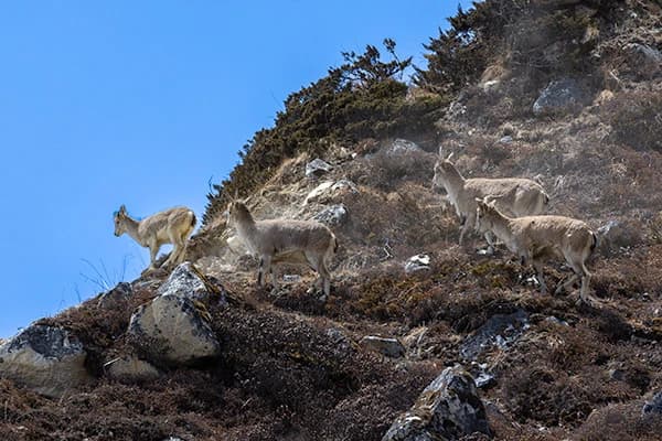
- Himalayan tahr: Wild goats in groups on rocky slopes
- Red panda: Rare, in dense rhododendron forests
- Blue sheep: Inhabits open alpine slopes.
The Manaslu Circuit Trek is also a treat for birdwatchers. Over 110 species of birds live here, along with three species of reptiles and several rare frogs found nowhere else nearby.
Realistically, most trekkers will not see a snow leopard. But signs of wildlife, tracks, droppings, and distant movement on the ridgelines are common enough to remind you this is still wild country.
The People of Manaslu: Nubri, Tsum, and Gurung Culture
Manaslu Conservation Area is not just a conservation area of nature but also a home. The people who have lived here for hundreds of years have been moulded by mountain life and Tibetan Buddhist tradition.
The main groups that you will encounter are
- Nubri: Inhabits upper Manaslu valleys, closely associated with Tibetan traditions
- Tsumba people: Found in the secluded Tsum Valley, celebrated for its ancient Buddhist traditions
- Gurung communities: settled in lower and mid-hill areas with their own language and traditions
Villages here often cluster around a monastery. Prayer flags line the trails, and man walls mark the path forward. Many locals still follow a lifestyle built around farming, herding, and small-scale trade, much as their ancestors did.
Tourism has slowly changed daily life too. Teahouses and homestays now give families an added source of income. Even so, the culture here remains intact, unlike in busier trekking regions.
For trekkers, the scenery is one of the biggest draws. You are not just walking through mountains. You are walking through living history.
Threats Facing the Manaslu Conservation Area
Even protected areas face real pressure. Manaslu is no exception. Some of the biggest challenges are;
- Climate change: Retreating glaciers and harder weather patterns to predict
- Increasing tourist numbers: More trekkers every year means more strain on trails, water sources and waste systems.
- Poaching threats: Protected species such as the snow leopard and red panda are still being hunted.
- Trekking trash in remote villages: A challenge for waste management with limited infrastructure.
- Pressure on deforestation: Local forests under strain from teahouse firewood demand
None of these threats is novel. But as the region’s popularity grows, they’re harder to ignore.
The good news is that awareness is growing too. Many lodges now use solar power instead of firewood. Guides increasingly educate trekkers on carrying out their own waste. Small steps, but ones that matter.
This balance between opening up to tourism and protecting what makes the area special is an ongoing challenge, not a solved problem.
Permits & Entry Requirements
Manaslu is a restricted area, which means you cannot just show up and start walking. A few permits are required before you begin. Here is what you will need:
| Permit |
Cost (Approx.) |
Notes |
| Restricted Area Permit (RAP) |
$100 per week (Sep–Nov) / $75 per week (rest of year) |
Price rises for extra weeks |
| MCAP (Manaslu Conservation Area Permit) |
$30 per person |
Required for the entire trek |
| ACAP (Annapurna Conservation Area Permit) |
$30 per person |
Needed since the route exits into Annapurna |
| Chum Nubri Rural Municipality |
$20 per person |
Chum Nubri Entrance Fee |
A few additional things to consider:
- You must trek with a licensed guide. Solo trekking is not allowed here.
- A minimum of two trekkers is usually required to get the Restricted Area Permit.
- Permits are checked at entry points such as Jagat, Philim, Namrung, Samagaon, and Dharapani, so keep copies handy.
- Trekking agencies usually do all the paperwork for you, which saves you a lot of hassle.
While the process sounds complicated, most trekking companies process everything in advance. All you really need to do is show up with your passport and passport-sized photos.
Best Time to Visit — Month by Month
Choosing the right time for your trek is important here. Weather and trail conditions shift a lot across the year.
Here is a simple breakdown:
| Months |
Season |
What to Expect |
| March–May |
Spring |
Clear skies, blooming rhododendrons, moderate temperatures |
| June–August |
Monsoon |
Heavy rain, leeches on lower trails, risk of landslides |
| September–November |
Autumn |
Best visibility, stable weather, busiest season |
| December–February |
Winter |
Cold, possible snow at high passes, fewer trekkers |
Autumn is generally considered the best window. Skies stay clear, and the Larkya La pass is usually safe to cross.
Spring is also a good time. Forests are in their prime and the temperatures are good for walking.
Monsoon season is best avoided. Trails become slippery, and views often disappear behind clouds.
Winter is possible too, but only for experienced trekkers. Snow can block the high pass, so flexibility is key if you choose this season.
Trekking Routes Through the Conservation Area
There is more than one way to explore this region, though most trekkers follow one main path with a few possible add-ons.
The core routes look like this:
- Manaslu Circuit Trekking route, starting from Machha Khola, crossing the Larkya La pass, and ending near Dharapani. Depending on your pace, it takes about 13 to 18 days.
- The Tsum Valley Extension is a possible trek to the remote Tsum Valley, which is known for its untouched Buddhist culture. It makes the trek longer by 5 to 7 days.
- People who go on treks sometimes extend their trips from Dharapani to the Annapurna region by connecting to trails like the Annapurna Circuit for a longer hike.
Most trekkers choose the standard circuit alone. It already covers a huge range of landscapes, from warm river valleys to icy high passes.
If you have extra time, the Tsum Valley add on is worth considering. It moves at a slower pace and feels even quieter than the main trail.
For those planning their trip, our full Manaslu Circuit Trek package covers permits, guides, and daily routes in detail.
Where to Stay & What to Eat
The places to stay here are simple, but most trekkers will be fine with them. You will be staying mostly in teahouses, small family-run lodges built along the trail. Here are a few things to expect:
- Rooms: Standard twin bed setup usually with shared bathrooms in lower villages
- Electricity: Available in most lodges, occasionally for a small charge
- Hot showers: More common at lower altitudes, less dependable higher up
- Tsum Valley homestays: A more personal option, staying with local families directly
Food is similar in that it’s simple yet filling.
- Dal bhat: Rice, lentils and vegetables, the trekking staple all over Nepal
- Tibetan bread: found in most of the higher villages and usually eaten with honey or jam
- Noodle soups: a popular warm food in higher, colder altitudes
- Yak cheese and butter tea are found mainly in Nubri and Tsum and are closely related to the local culture.
The higher you go, the more expensive things become, since everything must be brought in by porters or mules. Manaslu is still relatively inexpensive compared to other popular trekking areas.
For many trekkers, this simple food and lodging arrangement is part of the charm, not a negative.
Responsible Travel: Do's and Don'ts
Manaslu is not just scenic. It is a living community, and a restricted one at that. A little awareness goes a long way here.Some simple guidelines to follow:
- Do hire a licensed local guide. It is required, and it also supports the local economy.
- Do ask before photographing locals, especially in smaller villages.
- Do carry out your own trash. Waste systems here are limited.
- Do respect monasteries by removing shoes and staying quiet during ceremonies.
- Don't wander off marked trails, especially near pasture land or private farmland.
- Don't waste water. Many villages rely on limited natural sources.
- Don't bargain aggressively over food or lodging prices. Costs here reflect the difficulty of transport.
Small habits matter more than they seem. Trekkers who stay mindful of these guidelines help keep the region's culture and environment intact for the next visitors and for the people who call it home.
Responsible travel here is not about restriction. It is about respect.
Photography & Viewpoint Guide
If you know where to look, there are plenty of rewarding moments for photographers on this trail. You will have plenty of Manalu region photos while trekking.Some places to plan around:
- Budhi Gandaki Valley: Dramatic river gorges and suspension bridges—good for wide landscape shots
- Lho village: A close-up view of the mountain framed by a monastery in the foreground
- Syala Village: Open views of Mt. Manaslu (8163 m), especially beautiful at sunrise
- Sama Gaon: Culture, tradition and lifestyle of high Himalayan people from Manaslu region
- Larkya La Pass: The highest point of the trek, it offers sweeping views but the weather can be unpredictable.
Some tips to keep in mind:
- Typically the clearest skies are in the early morning hours before clouds build up later in the day.
- Villages like Lho, Syala, and Sama Gaun are worth a slower pace, since rushing through often means missing the best light.
- Bring extra batteries. Cold temperatures at altitude drain them faster than usual.
You do not need professional gear to capture this trail well. Even a phone camera can capture views like these, as long as you are patient enough to wait for the right moment.
Manaslu vs. Annapurna Conservation Area — Which Should You Choose?
While comparing Manaslu vs. Annapurna, both regions sit close to each other; however, the experience they offer is quite different. Here is a simple side-by-side look.
| Factor |
Manaslu Conservation Area |
Annapurna Conservation Area |
| Crowd levels |
Low, still relatively quiet |
High, one of Nepal's busiest trails |
| Permit cost |
Higher, due to restricted area fees |
Lower, more straightforward process |
| Guide requirement |
Mandatory |
Optional on most routes |
| Infrastructure |
Basic teahouses, fewer options |
More developed, wider variety of lodges |
| Cultural immersion |
Strong, less touristy villages |
Present, but more commercialized |
| Difficulty |
Similar, with a high pass crossing |
Similar, depending on chosen route |
If you want fewer crowds and a stronger sense of discovery, Manaslu is the better fit. If you prefer more comfort and flexibility along the way, Annapurna might suit you better.
Some trekkers even combine both, moving from Manaslu into Annapurna as one long, connected journey.
Explore Manaslu Region Packages
Ready to experience it for yourself? Here are all the ways you can trek through the Manaslu Conservation Area with us.
Whether you want the classic circuit, a slower cultural journey through Tsum Valley, or a shorter trek to fit your schedule, there is a Manaslu package built for you.
Ready to Trek the Manaslu Conservation Area?
Reading about it is one thing; walking through it is another. Few places in Nepal can match the Manaslu Conservation Area for its combination of wild scenery, friendly villages and peaceful trails. Whether you want the full circuit, a slower cultural route through Tsum Valley, or a shorter trek to fit your schedule, our local guides know these trails inside out. Book your Manaslu trek with Adventure Hikers and experience the Himalayas as they were meant to be seen today.